In case of an emergency, first responders like the fire brigade need up-to-date information. 2D maps are a common source of information but they can be difficult to read in an emergency situation. UT PhD-student Shayan Nikoohemat created an algorithm that can accurately generate 3D models of the insides of large buildings from point clouds.
Indoor 3D models are the digital twins of building interiors. The 3D models could be used by first responders to get a good impression of large buildings, like shopping malls, a hospital or a sports complex, on their way to the emergency. 2D maps represent important information – like the location of emergency exits – on tangled floor plans, making them difficult too read quickly and after each reconstruction, these maps are outdated. “Sometimes, these maps are so outdated that the real building looks completely different than the floor plans. We need a fast and reliable approach to create the digital 3D model of interiors.”, says Shayan.
From point clouds to 3d map
Luckily, laser scanners can quickly scan a whole building after every reconstruction. However, these scanners create point clouds, unstructured data which still has to be converted into a 3D model. The data doesn’t know if a scanned point is a wall, an exit or, for example, a table. According to Shayan, his program solved this: “For my PhD thesis, I created algorithms that automatically understand the data and can create 2D and 3D maps. We can detect and model doors, stairs, obstacles and navigable areas which are crucial data for the emergency planning.”
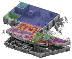
Figure 1: The point clouds and final 3D Model of the fire brigade building in Haaksbergen
Recognizing elements
The algorithm can recognize different structural elements such as walls, slabs, ceilings, and openings. Individual items like furniture, however, still pose a problem. “It is not yet able to correctly label everything, but the structural elements are enough to create an accurate map, which we tested on several real datasets,” he says. Huib Fransen of the Safety Region Rotterdam-Rijnmond was delighted with the results: “Shayan’s project is exciting for us and we were happy to provide him with the scanning sites for test cases.”
MORE INFORMATION
Shayan did his research and is now working as a postdoc at the Department of Earth Observation Sciences (EOS; Faculty ITC) and was supervised by Prof.Dr.Ir. M.G. Vosselman. His research project was initiated by the UT, TU Delft, and the Dutch FireBrigade (iNowit, Brandweer Nederland) and industry partners (CGI, Cyclomedia and Leap3D) and the Open Geospatial Consortium (OGC) to support disaster management in public buildings. The project was funded through the NWO Partnership Programme Map4Society. Shayan defended his PhD thesis, titled Indoor 3D Reconstruction of Buildings from Point Clouds, on 21 October.
More recent news
 Thu 11 Dec 2025Three new NAE Fellows and Young Engineer with UT background
 Thu 11 Dec 2025Two UT projects receive Perspectief grant
 Fri 5 Dec 2025Transforming urban policy for a healthier and safer Enschede (and other cities)
 Fri 28 Nov 2025UT celebrates 64th Dies: a look at the hospital of the future
 Fri 28 Nov 2025Van Damme scholarship for Lisa Deijlen and Wietske Woliner