Vegetation in riverine environments plays an important role in providing tools for nature-based solutions, which, as sustainable, cost-effective solutions, are urgently needed for river engineering and management. Vegetation covering channel beds, river banks and floodplains not only provide habitat, shelter and food for biological communities but significantly modifies the biological, chemical and physical environment (Tabacchi et al., 1998), which affects the water courses. Thus, proper river management requires understanding of the processes of mutual interactions (flow-biota), which are still challenging (Nikora, 2010; Nepf, 2012). However, the dynamic nature of vegetation requires sufficient studies of their seasonality for proper prediction of river processes.
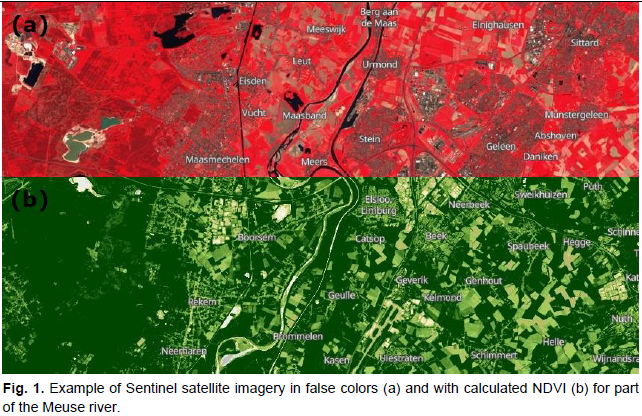
It is well known that the vegetation roughness varies throughout the year, which is commonly neglected in modelled predictions of river processes. To expand knowledge in this research field, the aim of this MSc project is to investigate seasonal changes in vegetation coverage and vegetation type as well on the riverbanks and floodplains based on satellite imagery (Fig. 1, example) in the part of Meuse River. The analysis of satellite images using GIS tools will allow:
- to determine changes in vegetation coverage over the entire year;
- to define NDVI and translate these values to roughness in order to produce spatial maps ofvegetation roughness.
Based on above mentioned objectives, the deliverable of this project will be preparation of vegetation roughness maps for different seasons of the specified area, which allow for more accurate representation of real vegetation characteristics in predictions of river processes. In addition, using programming skills, a generic framework in form of Python script will be developed which canbe used in the study of various areas and in different seasons to derive roughness information on the area of interest.
References
- Nepf, H. M. (2012). Hydrodynamics of vegetated channels. Journal of Hydraulic Research, 50(3), 262-279.
- Nikora, V. (2010). Hydrodynamics of aquatic ecosystems: an interface between ecology, biomechanics and environmental fluid mechanics. River research and applications, 26(4), 367-384.
- Tabacchi, E., Correll, D. L., Hauer, R., Pinay, G., Planty‐Tabacchi, A. M., Wissmar, R. C. (1998). Development, maintenance and role of riparian vegetation in the river landscape. Freshwater biology, 40(3), 497-516.
Supervision


Are you interested in this assignment? Contact the Master thesis coordinator.
