Rijkswaterstaat (RWS) aims to improve its understanding of the hydrological functioning of highways. If this is better understood, then current and future water challenges – such as those caused by a changing climate in terms of precipitation (totals, duration, intensity) – can be addressed more effectively. Potential problems can be anticipated and resolved or prevented earlier, allowing for better adaptation to climate change. This could help RWS reduce costs and fulfil its societal role more effectively.
When it comes down to the water balance of highways, runoff from and through the road surface is likely the largest component, but also the least understood. The runoff speed not only affects the excess of water that can infiltrate into the roadside or enter the drainage system, but it also affects the fraction of precipitation that evaporates from the porous asphalt (ZOAB), especially during summer, as well as the amount of water that splashes and leaves the road surface through this route. During periods of heavy rainfall, the runoff speed affects the saturation level of roadside buffers which can cause or prevent local flooding.
So far, research has mainly focused on the practical properties of ZOAB, specifically how fast water infiltrates into the asphalt (the so-called Becker test), rather than on accurately determining and influencing the water balance of a road section. Although some studies have examined runoff from ZOAB to assess the dispersion of harmful substances, these typically did not cover a sufficient time scale or surface area to provide insight into the hydrological functioning.
To better understand the rainfall-runoff response and water balance of highways, KnowH2O, in collaboration with Royal HaskoningDHV, has initiated a field experiment along a section of the A58 near Oirschot, commissioned by RWS. The goal of this experiment is to gain more insight into the drainage behaviour of ZOAB highways.
Using a collection pit (Figure 1) equipped with three flow meters, we measure runoff from a highway section (catchment area) of 20 x 12 meters (Figure 2). This pit also contains a pressure sensor to measure water levels. Additionally, the measurement setup includes a meteorological station that records the following variables: precipitation, relative humidity, air pressure, wind speed, wind direction, incoming radiation, and air temperature. In combination with nearby KNMI stations and fiveminute precipitation radar measurements from KNMI, we can calculate and apply precipitation and reference crop evaporation (using the Makkink method) for analysis at the test site.
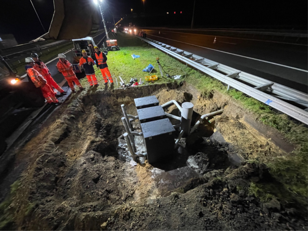
Figure 1: Collection pit with flow meters.
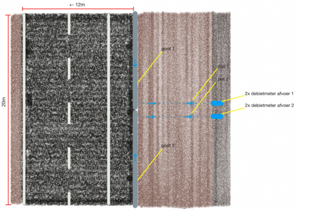
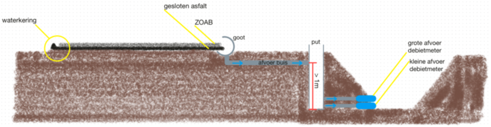
Figure 2: Top and side view of the measurement setup design at A58.
Assignment
Currently, we have one year of field measurements for this test site. For this assignment, we are looking for an MSc student to carry out a hydrological analysis using data from the experiment site and a model-based approach to simulate the rainfall-runoff dynamics during summer and winter, for prolonged rainfall as well as for peak rainfall events. Additionally, the model-based approach should provide insight in the other water balance components of the ZOAB highway section.
Additional project requirements
- Data analysis, building on existing work.
- Calibration and validation of the model/ tool using field experiment data, potentially supplemented with measurements from other sources (public data sources).
- Use of open-source tools, such as Python.
- Temporal resolution of the model/ tool: determine a relevant time step, possibly < 15 minutes.
- Utilize the calibrated and validated model to simulate several weather scenarios (scenario analysis).
- Validate meteorological field measurements against KNMI stations and radar data. Investigate the sensitivity of using meteorological data from external sources to assess whether the model could be applied without requiring local meteorological measurements.
- Deliverables: report/ manual + scripts/ tools.
- Practical aspects: working at the KnowH2O office in Nijmegen is an option and is preferred for 1–2 days per week.
References
- Bergsma, T., R. de Boer, R. Hulsman, I. Jensen (2023). Waar blijft het ‘wegwater’? Klimaatadaptatie rondom de snelweg. RWS en RHDHV. H2O-online.
- Naef, F., M. Margreth, S. Scherrer, P. Kienzler, R. Frauchiger, B. Baumann, P. Bürkel (2011). In-Situ-Abflussversuche zur Untersuchung der Entwässerung von Autobahnen. On-site runoff experiments on roads. Forschungsauftrag VSS 2003/205 auf Antrag des Schweizerischen Verbandes der Strassen- und Verkehrsfachleute (VSS).
- Van de Ven, F.H.M (1989). Van neerslag tot rioolinloop in vlak gebied. PhD Thesis. Technische Universiteit Delft.
- Zondervan J.G en A. Dommerholt (1975). Omvorming van neerslag tot rioolinvoer bij een bepaald type “inlet area”. Laboratorium voor Hydraulica en Afvoerhydrologie.
- Zondervan J.G (1978). Modelling urban run-off; a quasilinear approach. PhD Thesis. Centre for Agricultural Publishing and Documentation, Wageningen 1978.