ongoing Ph.D. / PDEng work
1. Making the third dimension count - 3D modelling and machine learning for urban property valuation
Ph.D. research of Yue Ying
Current property valuation studies mainly apply 2D geoinformation and 2D-based workflows to estimate property values and measure the influences of different factors. It is now being challenged at twofold. First, as urbanization accelerates, more population shift from rural to urban areas. The urban morphology is transformed by the growing number of buildings constructed for sheltering the increasing population, and it will keep evolving in the future decades. Profound changes happen in the vertical dimension concerning 3D geoinformation, but it fails to be captured in current property valuation, which will cause inaccurate property value estimates. Second, the current studies mainly adopt manual modelling processes, which is considered time-consuming and human-intensive.
This research aims to include the third dimension in property valuation in complex urban areas using cutting-edge technologies (3D modelling and ML). The overall methodology is inspired by design science research, which includes case studies with single- and multiple-case design, systematic literature review and experiment research.
The research outputs expect holistic requirements of experts and end-users for adding 3D data in property valuation, the selection and arguments of appropriate 3D modelling methods and ML algorithms for property valuation, and an integrated 3D property valuation workflow using 3D modelling and ML.
Publication: Ying, Y.; Koeva, M.; Kuffer, M.; Asiama, K.O.; Li, X.; Zevenbergen, J. Making the Third Dimension (3D) Explicit in Hedonic Price Modelling: A Case Study of Xi’an, China. Land 2021, 10, 24. https://doi.org/ 10.3390/land10010024
2, Data-driven modeling of Urban Heat Island
Ph.D. research of Monica Pena
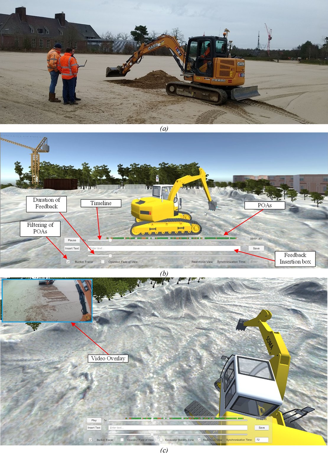
3. Application of Digital Twin in Construction Training; case of excavation feedback support system
PDEng project of Armin Langaroodi:
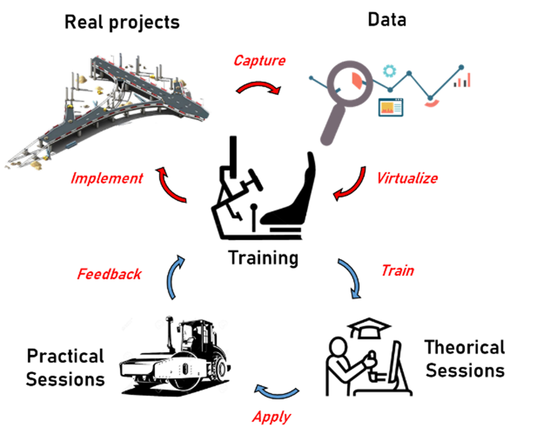
3. Application of Digital Twin in Construction Training; case of asphalt compaction training simulator
PDEng project of Sajjad Mowlaei
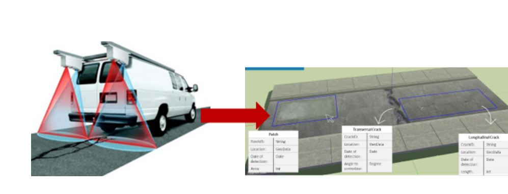
4. Digital Twin base representation of asphalt failure
PDEng project of Inga Maria Girogadze
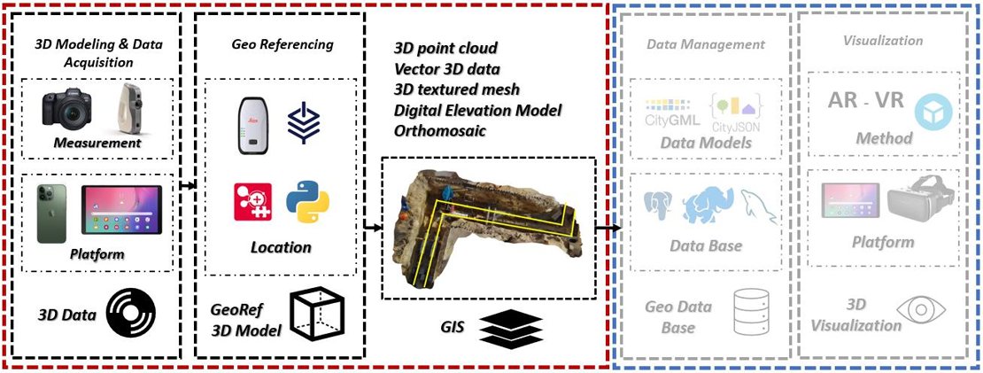
5. Smart Utility Registration: Towards Underground Digital Twinning
PDEng project of Nima Zarrinpanjeh
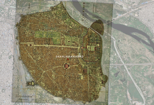
6. Modelling Cultural Heritage for Urban Planning: A Case of Shahjahanabad / Old Delhi
Ph.D. work of Shubham Mishra
The significance of cultural heritage as an intrinsic element of the urban landscape, its tremendous socio-economic and anthropological value, and its role as an enabler of sustainable development is well recognized in the global policy discourse. Thus, heritage has been included in the United Nations’ Sustainable Development Goals (SDGs) 11, whose target 11.4 aims to ‘strengthen efforts to protect and safeguard world’s cultural and natural heritage’. Geographic information science has long been used to support preservation of cultural heritage through documentation, modelling and information dissemination. However, the existing body of research in this domain shows such applications being skewed towards sites which are uninhabited or cultural artifacts that are mostly standalone in nature. This is in sharp contrast to cultural heritage sites in the global south which are often multi-layered, dense, still inhabited by a deeply rooted community and remain culturally vibrant despite widespread physical and socio-economic decay. Stuck in between the need to modernize and preserve cultural heritage, historic areas appear to be at crossroads. This often gets manifested in certain imprints of the past which are not clearly visible anymore and yet show their glimpses from every nook and corner. This lack of clarity makes it difficult to interpret them and get a clear sense of their significance.
Virtual 3D models or Digital Twins of such historic areas can help in revealing these imprints, better understand the historical evolution, map the patterns and relationships that may exist within the urban form and provide better urban planning and development solutions. This research aims to virtually reconstruct Shahjahanabad (also known as Old Delhi), the 17th century capital of Mughal India in 3D, across a spatio-temporal scale from 1638 CE to present times. In doing so, it looks to explore affordable methods of virtual reconstructions which are suited to physically dense and data poor environments like Shahjahanabad and the way in which such reconstructions can help in improving planning and management of historical cities.