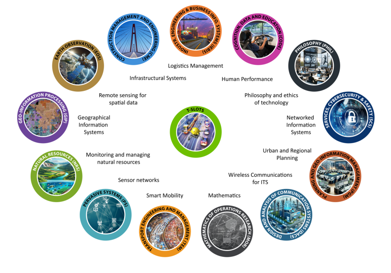
Welcome to the website of T-SLOTS: Twente Smart Logistics and Transport solutions. T-SLOTS is a bottom-up initiative from researchers within the University of Twente active in the fields of mobility, logistics and optimalization. Dedicated to the entrepreneurial high-tech human touch focus of the UT, T-SLOTS aims to be cross-disciplinary. Four out of the five faculties are involved and are jointly working on the developments and challenges of the fields of Twente Smart Logistics and Transport solutions.

Departments
Below, you can find a brief description of each of the departments within T-SLOTS. But if you wish to search on expertise or domain, please check out the Transport Expert Finder.
BMS - Cognition, Data and Education (CODE) - Drivers and operators training/learning in the real-world or in VR
- Digital twining, evidence-based design of AR and virtual agent support, cockpit design/prototyping
- Human performance, behaviour of traffic controllers, vigilance and attention in semi-automated driving; cognitive work analysis; state-of-mind detection; eye-tracking and EEG studies
BMS - Industrial Engineering & Business Information Systems (IEBIS) - Freight transportation
- Artificial Intelligence for logistics management
- Logistics decision-support systems and planning applications
- Analysis of alternative transport modes (electrification of fleets, autonomous vehicles like drones, delivery robots, AGVs, platooning, etc.)
- Philosophy and ethics of technology and engineering science.
- Interdisciplinary way of working.
EEMCS - Design and Analysis of Communication Systems (DACS) - Wireless Communications for Intelligent Transportation Systems
EEMCS - Mathematics of Operations Research (MOR) - Resource allocation and scheduling, Transportation and network routing problems, Traffic equilibrium models, Traffic light optimization, Network design, Online optimization, Queueing models
EEMCS - Pervasive Systems (PS) - Network of collaborative sensing, computational, and reasoning components (such as wireless sensor networks, Internet of Things, distributed networked systems) within transport and logistics
EEMCS - Services, Cybersecurity & Safety (SCS) - Networked information systems for the transportation/logistics domain
- Enterprise interoperability, data sovereignty, enterprise architecture, linked data and semantic web technologies, context-aware applications and services, IoT for real-time data, ontology-based domain modelling, requirements engineering, data security, blockchain applications, cyberthreat analysis and detection, machine learning-based threat modelling, privacy enhancing technologies, security testing
ET - Construction Management and Engineering (CME) - Data-driven, sustainability-informed decision support systems for the design, construction and life cycle management of transport and civil infrastructure systems
- Predictive models that estimate (i) the infrastructure systems condition and serviceability over time, and (ii) the impact of road pavement deterioration and driving conditions on rolling resistance
ET - Transport Engineering and Management (TEM) - Transport networks, land-use and transport interaction, travel behaviour and intelligent transport systems.
- Smart mobility, people transport planning, people transport engineering and management.
ITC - Earth Observation Science (EOS - Core remote sensing methodology
- Mathematical and statistical methods for geodata and earth observation
- Mapping of topographical objects.
- Spatial data infrastructure.
ITC - Geo-Information Processing (GIP) - Geographical Information Systems
ITC - Natural Resources Science (NRS) - Enabling society to effectively develop and use geo-information and earth observation knowledge and technologies for agricultural and environmental sustainability.
- Systems modelling, geographical information systems (GIS) and remote sensing (RS).
- Monitoring and managing of natural resources and the supply chains.
ITC - Urban and Regional Planning and Geo-Information Management (PGM) - Urban systems
- Empower society with specialized knowledge
- Expertise in spatial and temporal interactions between people, land tenure, land use, and urban systems
- Expertise in underlying governance processes to support inclusive planning and decision-making
Quick links

