Goals
We will utilize, integrate and further develop relatively low-cost, off the shelf, techniques to arrive at (1) an objective detection and quantification of defects in sewers and to (2) determine the constructive strength and stability of sewers. The integrated techniques form a proof of concept and findings will be documented in scientific papers and a practice guideline/manual.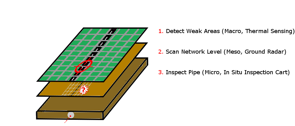
Abstract
This research aims to develop a converging three-stage approach for sewer condition assessment. The anticipated approach explores and integrates (1) long distance thermal infrared remote sensing (TIR) to identify ‘weak spots’ on areal level (macro), (2) Ground penetrating radar (GPR) to more closely inspect the local field conditions on street level (meso) and (3) in-situ sewage inspection carts to sense local conditions on pipe level (micro). The three stage approach (see below) deviates from traditional sewer inspections that use only one in-situ tool at a time to assess network conditions. Although these ‘single-technology’ approaches have their unique features and constraints, they have not been successful in conducting a comprehensive and objective utility inspection. Recent research therefore integrates multiple technologies to effectively and objectively inspect sewage networks (e.g. Atef et al. 2016). The proposed research follows this path, and utilizes, integrates and further develops relatively low-cost, off the shelf, techniques to arrive at an objective detection and quantification of defects, and to determine constructive strength and stability of sewers. In essence, we first explore the value of TIR to detect and evaluate potential “problem” locations (complementing the work of (Fahmy & Moselhi, 2009; Weil, 1995; Wirahadikusumah et al., 1998)). Second, we explore quantitatively the sewer conditions with GPR; and, third we mobilize in-pipe inspections to locally quantify sewer conditions. To store, filter and analyze sensor reading data we build upon existing concepts from Building Information Modeling literature and develop a subsurface information system (SIS) toolkit.