Species Localization - GeolifeCLEF
Problem Statement:
Automatic prediction of the list of species most likely to be observed at a given location is useful for many scenarios related to biodiversity management and conservation. First, this would allow to improve species identification tools - automatic, semi-automatic, or based on traditional field guides - by reducing the list of candidate species observable at a given site. More generally, it could facilitate biodiversity inventories through the development of location-based recommendation services (e.g. on mobile phones), encourage the involvement of citizen scientist observers, and accelerate the annotation and validation of species observations to produce large, high-quality data sets. Finally, this could be used for educational purposes through biodiversity discovery applications with features such as contextualized educational pathways.
The aim of this competition is to predict the localization of plant and animal species.(ref: Kaggle-GeolifeCLEF 2021)
Task:
- Literature review on the previous GeoLifeCLEF works.
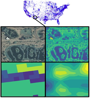
- Develop automatic species localization model from multimodal inputs like Remote sensing RGB image, Land cover data, Altitude data, Bioclimatic data, Pedologic data.
Work:
20% Theory, 50% Simulations, 30%Writing
Contact:
Andreas Kamilaris – a.kamilaris@utwente.nl
Chirag Padubidri – c.padubidri@cyens.org.cy