Using Artificial Intelligence in Real Estate:
Can we understand the condition of a building from above?
Can we understand the condition of a building from above?
Problem Statement:
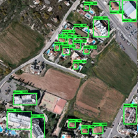
Geo-analytics is about the use of location-based information in analyses for contextual awareness and situational understanding. This information usually comes from high-spatial-resolution satellite imagery. By incorporating geo-location and other spatial details, businesses can gain a broader understanding of big data scattered in physical space and time, uncovering new insights and new efficiencies. The use of geo-analytics enables comparisons among different locations and may be used to identify trends and patterns, both locally and regionally. Geo-analytics is usually combined with artificial intelligence and computer vision, to perform high-resolution land cover mapping and identify cues that describe the quality and condition of buildings, to understand their status and market value.
Task:
The general aim of the project is to employ high-spatial-resolution satellite imagery, together with advanced state-of-art computer vision techniques (i.e. deep learning), in order to derive and infer the quality and condition of buildings, based on the satellite photos which view the buildings from above. More precisely, the following aspects need to be determined and classified:
- Ranking of building quality as can be considered from its rooftop
- Ranking of building quality as be considered based on the presence of vegetation surrounding some property
Work:
10% Theory, 60% Modelling, Coding and Testing, 20% Evaluation and Validation, 10% Writing
Contact:
Andreas Kamilaris: a.kamilaris@utwente.nl