

Describe your student years in three words.
- Tracy

Educational, explorative, and fun.
Why educational?
- Tracy

I did my Bachelor’s in Geospatial Engineering in Kenya, which was an introduction to remote sensing and geographic information systems (GIS) and mostly focused on theory. I wanted to put remote sensing and GIS into practice. During my Master’s in Spatial Engineering at the University of Twente, I finally got to apply that theory to real-world projects. I was involved in developing solutions by using remote sensing data and GIS to help stakeholders reduce flooding and its impact in Enschede, to improve food security in Maasai Mara (Kenya), and to reduce earthquake risk and impact in Groningen. These are what we call wicked problems: complex challenges that don’t have easy solutions.
What memory from your student time still stays with you?
- Tracy

We built a close-knit community at the ITC hotel, where I spent every day with people from all over the world: India, Nepal, Kenya, Ghana, Zimbabwe, Saudi Arabia, and more. We cooked together, travelled across the Netherlands, and went on study trips to visit organisations working in spatial engineering. Spending time with all those people taught me to lead with respect, even if I didn’t understand their beliefs, religion, or culture. My favourite memories are related to a tradition we started: on birthdays, we surprised the person with a cake at midnight. It was a small but beautiful gesture.
You are now a geospatial data analyst at Rabobank. What do you do?
- Tracy

Rabobank is known for its focus on the food and agriculture sectors. In my role, I use satellite and GIS data to analyse agricultural regions and help clients, farmers, or internal teams at Rabobank make informed decisions. For example, my last project supported small-scale farmers to transition to agroforestry. The idea was to plant more trees, but the question was, "Where would it be most impactful to do that? Should we just plant anywhere?” I built an interactive map that supported stakeholders in identifying areas that would benefit the most from agroforestry.
By analysing GIS data and modelling, I could identify whether an area was affected by soil erosion, whether it was very hot and would benefit from tree shade, and what the poverty level and population density were, as we wanted places where lots of people could benefit from agroforestry. The tool I built is public and is meant to help agroforestry stakeholders make better-informed decisions.
What motivates you in your work?
- Tracy

Making an impact on people’s lives, such as farmers, is what motivates me. In the above-mentioned project, I worked with smallholder farmers: people with one hectare of land or less. The tool helps identify regions where they would benefit the most from agroforestry, so I am helping create opportunities for people who need them.
Why did you choose this job?
- Tracy

It is a funny story. I didn’t get the job I applied for, which was a GIS analyst role. However, I reached out to the manager and asked if I could do an internship or consultancy on a different project. I wanted to build a portfolio, even if it was just for three months. She said yes to a short contract project, and my contract was extended later, while my role has transitioned over time.
What have you taken from your studies in Spatial Engineering into your job?
- Tracy

I would say everything. The practical application of remote sensing and stakeholder engagement is central to my job. Whether I am solving a problem such as tree mortality or finding the most suitable location to grow crops, it is always about understanding the problem, using remote sensing and GIS, and working with stakeholders.
And what did you learn on the job?
- Tracy

I am still expanding my knowledge of GIS, remote sensing, and programming. And since I work at a bank, I have learned a lot about data privacy and security.
What do you want to achieve professionally in 10 years?
- Tracy

I would love to lead a remote sensing team. I have had managers who gave me opportunities and supported me, and I want to be that kind of manager one day. In the coming years, I will focus on building expertise in remote sensing and leadership skills so that I can guide and motivate a team of my own.
What is your advice to students?
- Tracy

Don't give up. Have the courage to show up, to network, and to ask people for what you want, just like I did. Also, build a portfolio to show what you can do. Spatial engineering is a relatively new field, and not everyone understands what you do. You have to show them.
Come study at the University of Twente
Did you like this article? Then you might find these study programmes interesting as well.
Related stories
 student GraduatesFrom student to learning technology specialist: “I enable learning for employees.”Fatema is a learning technology specialist at Boskalis, a global company providing construction and maintenance of maritime infrastructure services. She completed the Master’s in Educational Science & Technology at the University of Twente.
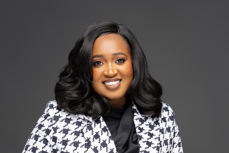 student GraduatesFrom student to geospatial consultant: “I support food security and emergency response.”Stella is a geospatial consultant with experience at the UN Food World Programme, the world’s largest humanitarian organisation bringing food assistance during emergencies, and the International Fund for Agricultural Development (IFAD). She completed the Master’s in Geo-Information Science & Earth Observation at the University of Twente.
 student GraduatesFrom student to integrated circuit design engineer: “I design chips that support people’s health.”Oğuz is an integrated circuit (IC) design engineer at Sencure, a start-up developing chip technology for wearable medical devices. He completed the Master’s in Embedded Systems at the University of Twente.