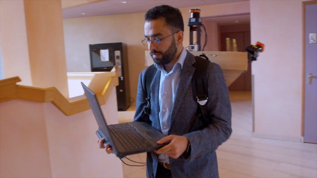
In case of an emergency, up-to-date information about the inside of buildings needs to be readily available for first responders. UT researcher Samer Karam developed a wearable mapping system (the ITC-Backpack) that can map building interiors in mere minutes.
Many large public buildings can get quite complex to be accurately mapped. Floor plans (2D maps) represent only important information and can become tangled in complex buildings. They are often difficult to read quickly. To make matters worse, after every reconstruction or renovation process, these maps are outdated. In the case of an emergency, it is important to understand the current situation at a glance. Indoor 3D maps can be the solution.
The spread of COVID-19 raised awareness about the importance of 3D indoor mapping. Digital maps of indoor spaces can help for ensuring social distancing, virtual tourism and real-estate decision making without the need of showing up in person.
3D Indoor Mapping
Traditional mapping methods depend on static devices, such as terrestrial laser scanners, which take long and can become expensive. They require setting up the device at many different positions Thus, an accurate 3D scan can take hours. For his PhD defence, UT-researcher Samer Karam, developed the ITC-Backpack, a wearable mobile mapping system that can digitize building interiors quickly and at high levels of detail.
ITC Backpack
The system consists of three 2D light detection and ranging (LIDAR) scanners and an inertial measurement unit (IMU). The LIDAR scanners provide laser points. “They record points on the surrounding walls, ceiling and floor,” explains Karam. The IMU measures the accelerations and angular velocities of the backpack over time. This data is used to estimate the pose changes. As global navigation satellite systems (GNSSs) don’t work inside buildings, the ITC-backpack employs a simultaneous localization and mapping (SLAM) algorithm developed during the research trajectory of Karam. “It is LIDAR-IMU-based SLAM that relies on planar structures in the indoor built environments,” he explains.
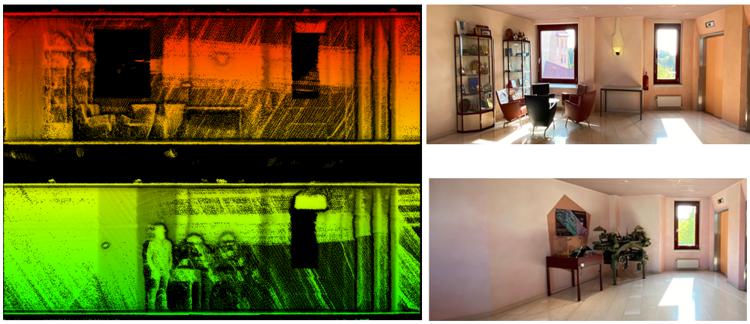
Figure 1: 3D point clouds and their respective indoor locations.
Loop closure
Creating a 3D map from these 2D data points proved to be difficult. “The sensor noise, pose estimation errors and the complexity of some buildings result in a drift after a while,” says Karam, “When I walked around the first floor in the ITC building and came back to the starting place, the system duplicated the walls of the corridor with some drift. To solve this I developed a specific loop closure technique that makes the backpack system recognize the previously visited places and corrects the drift.”
Testing the system
The backpack was tested in several public indoor environments with various levels of complexity. Karam tested the ITC-Backpack in the Institute of Geodesy and Photogrammetry building at the University of Braunschweig in Germany, the Fire Brigade building in Haaksbergen and several buildings at the University of Twente in the Netherlands. “I even validated the system on the hall that hosted my PhD defence,” says Karam.
More information
Samer Karam was a PhD candidate in the Department of Earth Observation Sciences (EOS; Faculty of ITC). His supervisors were Prof Dr George Vosselman and Dr Ville Lehtola from the Faculty of Geo-Information Science and Earth Observation (ITC). Karam defended his PhD dissertation, titled Developing a SLAM-based Backpack Mobile Mapping System for Indoor Mapping, on 27 October. He is currently working in the department of Earth Systems Analysis (ESA) as a postdoctoral researcher in the Ingenious project. That project has a strong focus on the use of drones to make the work of first responders safer and more effective. The project is funded by the European Union’s Horizon 2020 research and innovation programme and the Korean government. Karam is responsible for developing a micro drone to map areas that are inaccessible due to safety reasons such as hazardous sites.
Interview with Samer Karam by 1Twente (2 parts from 2:30 - 16:17 and 38:12 - 43:30)


