Researcher Irene Garcia-Marti of the University of Twente mapped the distribution of ticks in the Netherlands. For the first time, it is possible to view the daily tick activity in the Netherlands on a map at an unprecedented level of detail. In the northeastern provinces the tick activity is maximal. Along the coast you will find the lowest number of ticks.
Every year, approximately 25,000 people in the Netherlands are infected with Lyme borreliosis (LB), a disease transmitted by ticks. UT researcher Dr. Garcia-Marti mapped the distribution of ticks in the Netherlands at an unprecedented level of detail. In her research, she combined citizen observations with weather data, satellite vegetation measures, land use and land cover with data-driven methods.
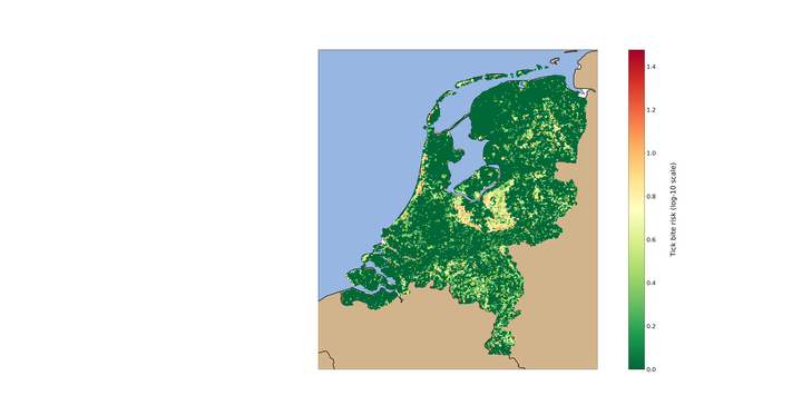
Fig. 1: Tick bite risk map
The places where most people recreate in nature are the places where the most tick bites occur. At present, visitors to recreational areas, city parks and suburban forests are most at risk of contracting Lyme disease. So although the number of ticks in coastal areas is low, these are still the 'high risk areas'. The coastal recreation areas from the Frisian islands to Middelburg are the areas with the highest risk of tick bite. This is followed by the Utrechtse Heuvelrugbos and the southern edge of the Veluwemeerpark.
Solutions
The research results can help to set up campaigns and implement strategies to reduce the risk of infections. Awareness campaigns, for example, in high-risk areas can have a positive effect. Garcia Marti: "If you use the right protection in the form of tick repellent trousers, socks over the trousers and daily checks after visiting nature, the risk of a tick bite is zero."
Garcia-Marti recently obtained her PhD in the Geo-Information Processing (GIP) department of the Faculty of Geo-Information Science and Earth Observation (ITC) at the University of Twente. Her dissertation is entitled: "Modelling and mapping tick dynamics using volunteered observations". Read more on her personal website https://irenegarciamarti.com. The maps can also be found here. The citizen observations used by Garcia Marti were collected by researchers from the RIVM and Wageningen University & Research.
Note for the press
For more information or interview requests, please contact dr. Irene Garcia Marti, 0628795342. Or press officer Kim Hovestad, 0622436275.


