Having invested strongly in creating an automated satellite image processing system, the first results of the STARS project are becoming visible. The project, led by the Faculty of Geo-information Science and Earth Observation (ITC) of the University of Twente, is now two years on its way.
After several cycles of designing, implementing, debugging and establishing a collection of algorithms, the researchers are confident that a fully-automated Very High Spatial Resolution (VHSR) satellite image processing system is now in place. Dimitris Stratoulias explains that the system addresses some of the prevalent specifications and needs of smallholder farming remote sensing and can extract information for farm management in near-real time (see Figure 1).
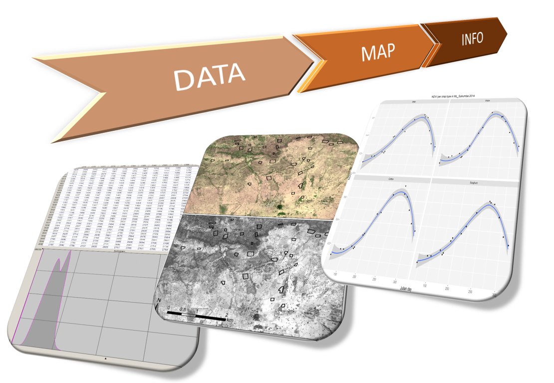
Fig 1: STARS has developed a fully-automated satellite image processing system that can extract relevant information for farm management units from Very High Spatial Resolution (VHSR) satellite data.
Need for accurate farm management information
Smallholder farmers in sub-Saharan Africa and East Asia often cultivate small plots with fuzzy boundaries, where they often grow multiple crops and crop varieties at the same time. Moreover, there is a rich variety of farm practices in place that adds to the heterogeneous mosaic that African and Asian farmland often is. These conditions make it hard to discriminate crops, cropping systems, and cropping practices from the skies. This presents a fundamental barrier to the provision of accurate information, and to the offering of improved agricultural advisory services.
Processing workflow
Practically, the system is a processing workflow that transforms VHSR raw satellite images to crop-related information about individual smallholder farm plots. This workflow comes from the early realization that an automated process was needed to analyze vast collections of images. The STARS workflow is fully based on free (and also largely open source) software, such as R, Python, the Orfeo toolbox, and bash scripting, and It has been tested and applied on a multi-sensor image archive of over 270 VHSR images of WorldView-2, WorldView-3, QuickBird, GeoEye and RapidEye acquired over five different experimental areas in sub-Saharan Africa and South-East Asia.
The workflow delivers two types of product (see figure 2). First, a pre-processing chain produces intermediate image products needed in most remote sensing studies; these products are atmospherically corrected, mosaicked, ortho-rectified, and image-to-image geo-registered images, as well as tree and cloud masks for each of the images. Secondly, information specific to farm management units or to crop types is generated during the season. Examples of this information are the mean and variance of the reflectance of a field, or the temporal evolution of several vegetation indices and textural characteristics. This information is stored in a database, the so-called Crop Spectro-temporal Signature Library (CSSL), which is currently available to STARS project partners, but soon also to the general public.
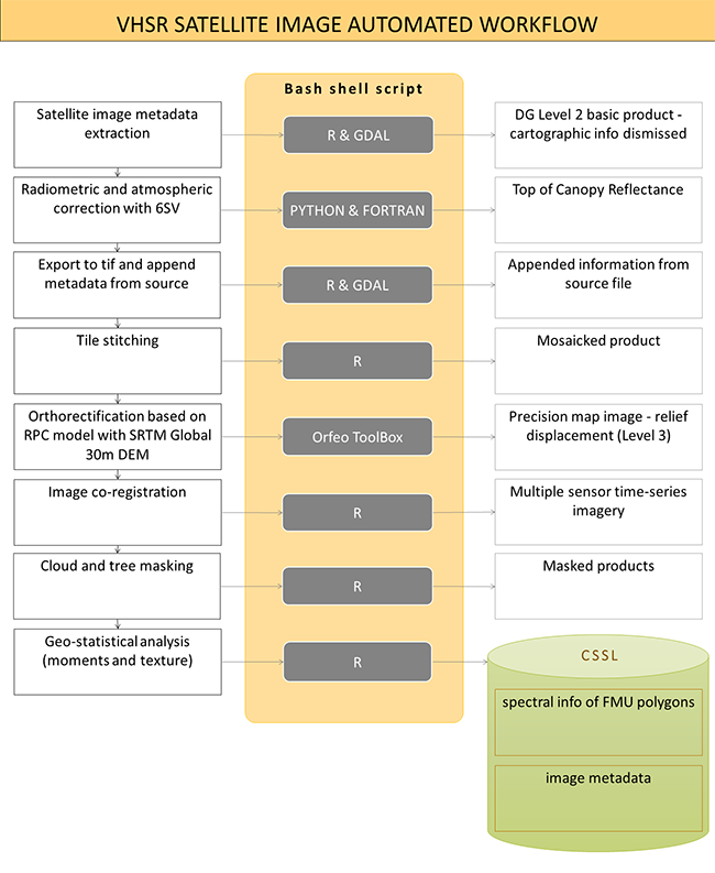
Fig 2: The STARS satellite image workflow delivers two types of products. First, a full pre-processing chain produces image products typically needed in remote sensing studies (white boxes on the right); Second, statistically-extracted information is stored in a database, the so called spectro-temporal spatial database (CSSL).
By making available the STARS satellite image workflow to the general public as a project outcome, we hope to equip other teams in the timely and routine pre-processing of VHSR images. The workflow supports teams in studies related to smallholder farming as it allows to:
- easily make available useful satellite image-based datasets,
- deliver farm- and crop-specific information to decision-makers of all sorts: agricultural agencies, private sector entities in agriculture, farmer communities to support their decision making,
- support studies on smallholder farming in developing countries by African and Asian scientists who can base their agricultural remote sensing efforts on a free and open source collection of algorithms.
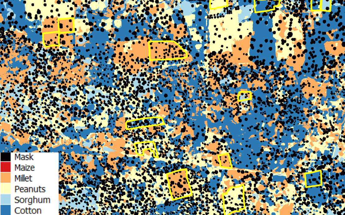
Fig. 3: A subset of one of the crop maps produced for the STARS study area in Mali. The yellow polygons indicate smallholder farms with ground truth information and the black areas show the high density of trees inside the farms.
Application
An example of a scientific application that leverages the output of the satellite image workflow was demonstrated at the STARS Results Sharing Meeting in Arusha, Tanzania in July 2016. This application shows that a classification of a time series of WorldView images can be used to accurately map the main agricultural crops over our study area in Mali. The classification was based on thousands of spectral and textural features derived from the images using a cloud computing environment, namely the Google Earth Engine.
The tree and cloud masks produced by the STARS workflow were used to guarantee that the classifier was trained and was applied to crop pixels only, ensuring a more accurate classification and the production of a more realistic map of the study area. Moreover, as Raul Zurita-Milla indicates, Google Earth engine can process millions of pixels in just a few seconds so that maps can be produced in a timely manner.
Progress
“Our results so far are utterly encouraging,” says Rolf de By. “The automated workflow equips anyone with an interest in mapping smallholder farming with tools to use satellite images without the need for deep expert knowledge. The analytical algorithms that are now being developed are expected to inform us where all the crops are. This will be the starting point of a next batch of analysis questions: how well has the maize done this year? Are farmers using crop rotation methods?”
About STARS
ITC is lead partner in the STARS project: a two-and-half year research project that is looking for ways to use remote sensing technology to improve agricultural practices in Sub-Saharan Africa and South Asia. Supported by the Bill & Melinda Gates Foundation, the project hopes to significantly advance the livelihoods of smallholder farmers in some of the world’s poorest countries.


